
Vijayapura Urban Development Authority Approves Master Plan 2031
By GumbazExpress News Desk | Vijayapura | Urban Development
The Vijayapura Urban Development Authority (VUDA) has finalized the Master Plan (Revision-II) 2031 for the Vijayapura Local Planning Area, outlining zoning regulations, land use distribution, and development standards under the Karnataka Town and Country Planning Act, 1961.
The document divides the city into clearly defined zones for residential, commercial, industrial, public, and agricultural uses to guide long-term urban growth and maintain public health and safety standards.
Two Development Zones Identified
The plan categorizes Vijayapura into:
- Zone A: Intensely developed area (within the inner fort wall)
- Zone B: Moderately developed area (outside the fort wall)
Each zone has its own building and development regulations, including plot size, floor area ratio (FAR), setbacks, and permissible height of structures.
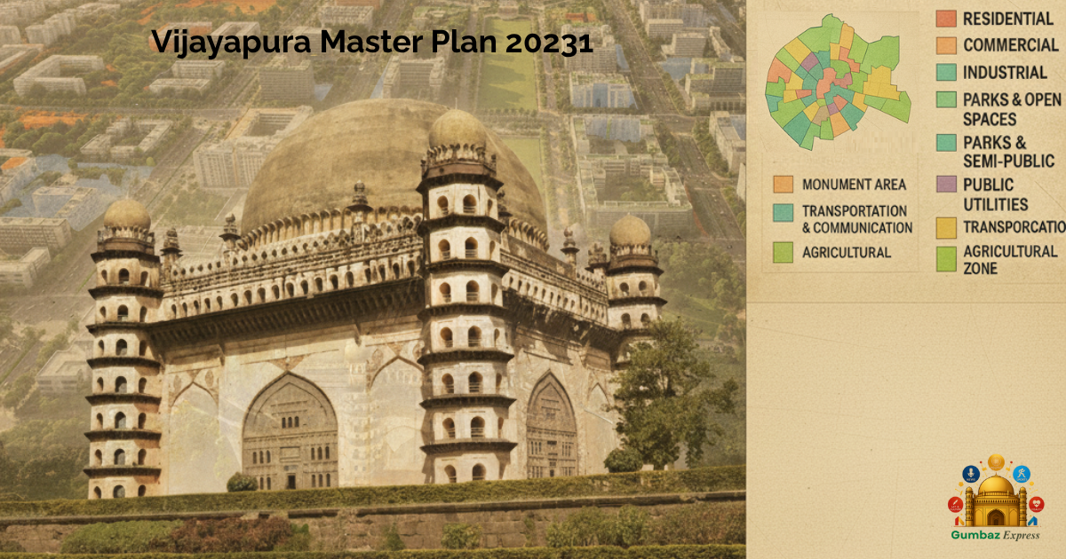
Nine Primary Land Use Categories
The Master Plan identifies nine major land-use classifications:
- Residential
- Commercial
- Industrial
- Parks and Open Spaces
- Public and Semi-Public
- Public Utilities
- Monument Area
- Transportation and Communication
- Agricultural
Residential and Commercial Development
Residential zones include plotted housing, group housing, villas, and service apartments.
The Commercial Zone allows offices, retail establishments, educational institutions, hotels, and multiplexes.
Minimum plot and road width requirements are defined — 12 metres for small commercial use and up to 18 metres for heavy commercial and logistics activities.
Industrial Development
Industrial zones are designated for small-scale, medium, and select heavy industries, subject to clearance from the Karnataka State Pollution Control Board (KSPCB).
Permitted uses include MSMEs, warehouses, cold storage, and logistics hubs.
Open Spaces and Buffer Zones
As per the Urban Development Department circular (11 August 2021), the plan prescribes buffer zones to protect natural drainage and water bodies:
- 30 m from lakes/tanks
- 30 m from primary drains
- 15 m from secondary drains (>12 m width)
- 9 m from smaller drains (6–12 m)
- 6 m from minor streams (<6 m width)
Only limited infrastructure such as walking tracks and playfields is permitted in these areas.
Heritage and Monument Protection
A 100-metre “No Development Zone” is established around the fort wall and protected monuments, with an additional regulated area up to 300 metres under the AMSAR Act, 2010.
Any work in these zones requires prior approval from the Archaeological Survey of India (ASI) or the Department of Archaeology and Museums, Karnataka.
Public and Utility Infrastructure
Public and Semi-Public zones are reserved for institutions such as schools, hospitals, cultural centers, and government offices.
Public Utilities zones cover essential infrastructure including power substations, water treatment plants, gas pipelines, telecom towers, and solid waste facilities.
Transport and Connectivity
The Master Plan allocates space for bus and truck terminals, railway depots, multi-level parking structures, and cargo terminals.
These facilities aim to enhance mobility and strengthen Vijayapura’s connectivity with regional trade and logistics networks.
Agricultural Zone and Peripheral Growth
Agricultural areas will continue to support farming, horticulture, and renewable energy projects such as solar and wind installations.
Farmhouses up to 7 metres (G+1) are permitted, along with agro-processing and food-packaging units under Schedule III.
Implementation and Enforcement
The Zonal Regulations form part of the legally binding Master Plan (Revision-II) 2031, enforced under the Karnataka Town and Country Planning Act, 1961.
Existing land uses that predate the plan are classified as non-conforming uses and will be gradually phased out without hardship to property owners.
The detailed plan, maps, and regulatory annexures are available with the Vijayapura Urban Development Authority (VUDA) for reference and compliance.
Source:
Vijayapura Urban Development Authority — Master Plan (Revision-II) 2031 (Final Report)
Prepared under Clause (iii) of Sub-Section (2), Section 12, Karnataka Town and Country Planning Act, 1961.
The plan divides Vijayapura into two development zones — Zone A, covering the intensely developed areas within the fort wall, and Zone B, covering moderately developed areas outside it. It outlines regulations for building heights, plot sizes, road widths, and land use to ensure systematic urban expansion.
Nine major land-use zones have been identified: Residential, Commercial, Industrial, Parks and Open Spaces, Public and Semi-Public, Public Utilities, Monument Area, Transportation, and Agricultural zones.
The Master Plan prescribes minimum buffer zones around natural and heritage assets — 30 metres around lakes and major drains, and a 100-metre “no development zone” near the city’s fort wall and protected monuments, as per the AMSAR Act 2010.
Industrial development will focus on small and medium enterprises (MSMEs), cold storage, logistics, and research units, while the agricultural zone will allow renewable energy and agro-based processing activities.
Public and Semi-Public areas have been earmarked for schools, hospitals, and government institutions. Dedicated spaces for transport infrastructure — including bus terminals, railway depots, and cargo hubs — are also planned to improve connectivity.
The Zonal Regulations form part of the statutory Master Plan 2031, which will be implemented under the Karnataka Town and Country Planning Act.
Detailed land-use maps and regulations are available with the Vijayapura Urban Development Authority (VUDA) for public reference.
📍 Source: Vijayapura Urban Development Authority – Master Plan (Revision-II) 2031, Final Report